The Ubaye alone brings together three of France's finest navigable runs for rafting . With no dam or artificial impoundment along its entire length, it has kept the character of a wild river — 50 km of navigable whitewater, from Class II to Class V, from the Haute-Vallée down to Lac de Serre-Ponçon.
Navigable runs
The Ubaye rises at the Col du Longet, near the Italian border 🇮🇹, and flows into Lac de Serre-Ponçon. Its whitewater sections are divided into three zones:
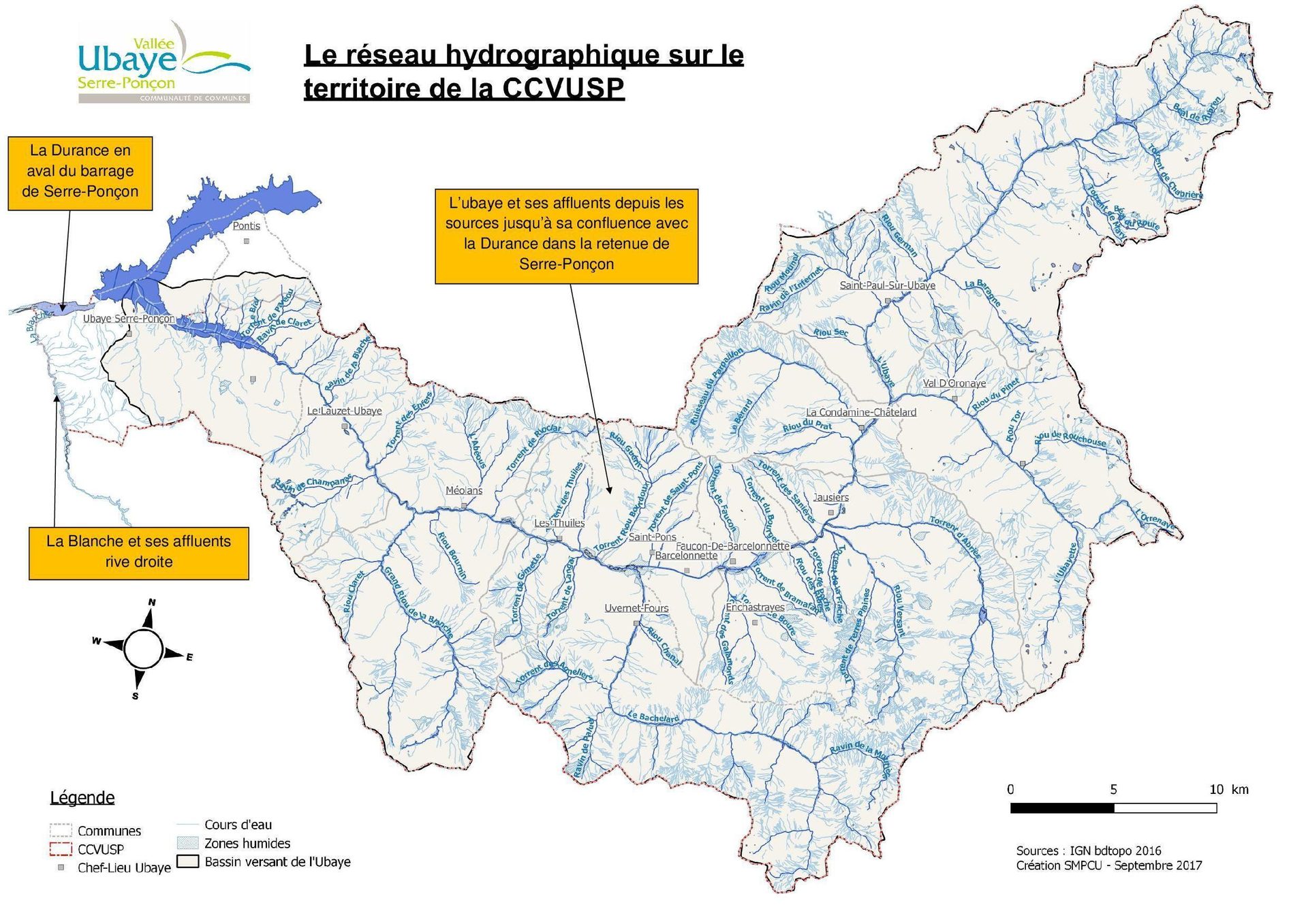
- Haute Vallée — downstream from Saint-Paul-en-Ubaye, from the Riou-Sec to the village of Faucon de Barcelonnette. An intermediate and fairly committing section, reserved for experienced paddlers, navigable mainly in spring.
- Basse Vallée — des Thuiles jusqu'au Lauzet, en aval de Barcelonnette. C'est là que se
déroulent la quasi-totalité de nos descentes sur 3 parcours :
- « Teufeu » — from Les Thuiles to La Fresquière (6 km)
- « Exs du haut » — from La Fresquière to Le Martinet (3 km)
- « Meuleu » — from Le Martinet to Le Lauzet (9 km)
- Gorge Royale (« Exs du bas ») — the final section before Lac de Serre-Ponçon (6 km), downstream from Le Lauzet, with an international reputation. The run from Rioclar (upstream of La Fresquière) to the lake is one of the finest sequences of rapids in France.
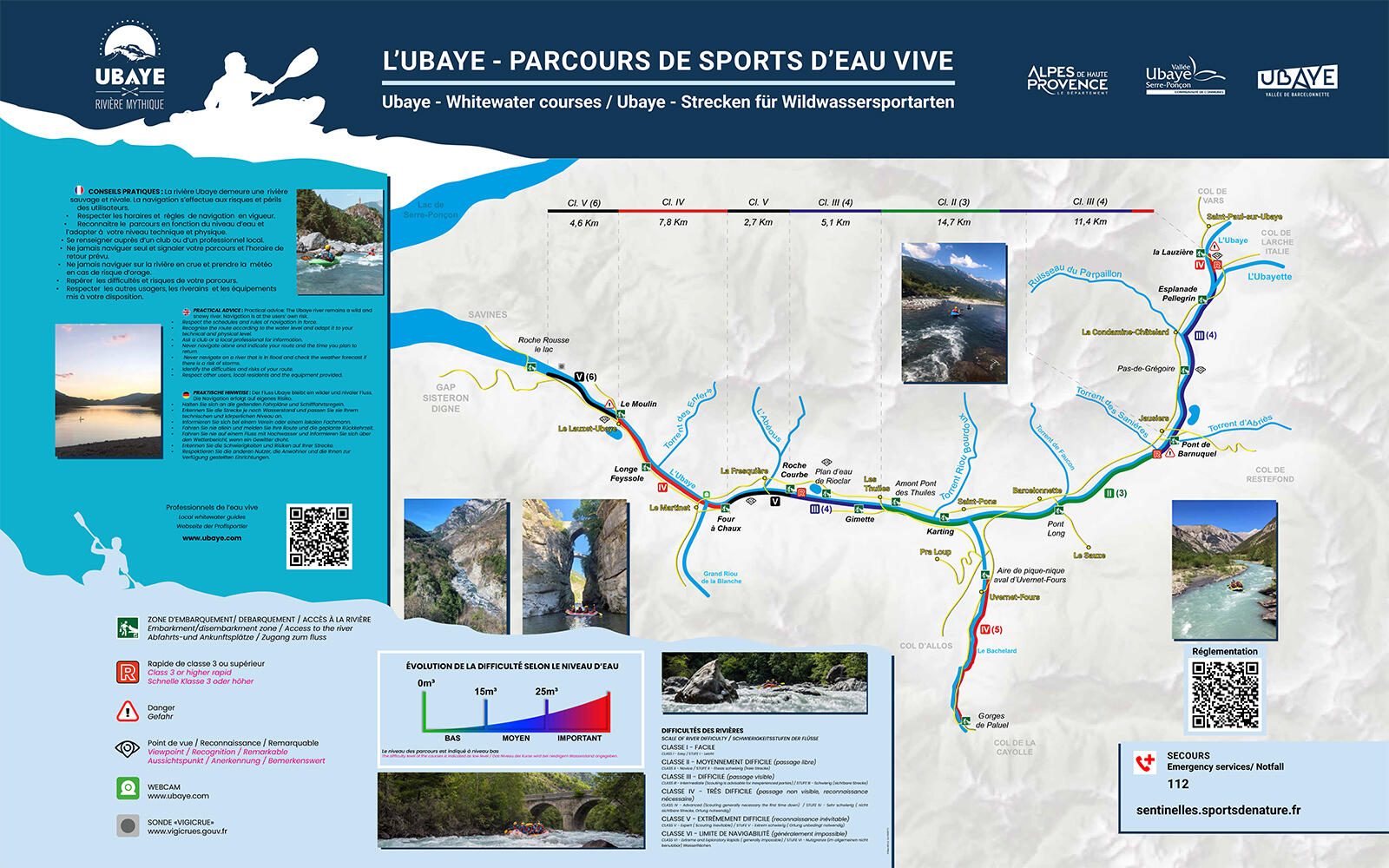
River classification
- Class I — Easy: steady current, small waves, simple obstacles.
- Class II — Beginner: irregular current, small waves, minor rapids.
- Class III — Intermediate: waves, water features and marked rapids, sometimes requiring manoeuvring.
- Class IV — Advanced: continuous waves, powerful holes, technical rapids and significant drops.
- Class V — Expert: rapids that must inevitably be scouted, dangerous obstacles.
- Class VI — Potentially runnable depending on water level. Serious hazards.
Source: Annex III-12 (Article A322-43) of the French Sports Code.
Rapids with unlikely names
From Class II to Class V, more than 30 rapids define the course of the Ubaye — with names that say everything about their character:
La ligne droite du martinet, le rapide du riou, le rapide de la centrale, la cuisine, la trompette rock, le coude à Makdosch, la pile à Makdosch, le rouleau de printemps, le plat de résistance, les 3 rivières, le photographe, Champanastaïs, les enfers, Hollywood, la moustache, la digue, le dinosaure, la maxi-vague, la dent de requin, le rocher de l'allemand, le bois des hoches, la sirène les petites gorges, la tortue, le vélodrome, le siphon, l'aspirateur les grandes gorges, le rapide des gorges, l'étroiture, la baleine, la piramide, le drossage, la proue.
Live: the Méolans-Revel webcam
The camera is installed at the Pont du Martinet (take-out for Exs du haut and put-in for Meuleu), 400 m upstream from our base — image updated every hour. A useful gauge of water level before you book.
