The Arrival of the Railway in the Barcelonnette Valley
Once upon a time, there was the epic story of the Southern Alps railway, in the Barcelonnette Valley. A remarkable adventure is told once again in this blog. It is a defining historical episode of our beloved Ubaye Valley.
The Railway in the Ubaye: A Colossal Gamble
La construction de ce projet fut un défi immense. Devoir tracer une ligne ferroviaire au milieu d'un massif alpin accidenté comme on peut l'imaginer. Respecter une pente n'excédant pas les 4 % au milieu de ce relief montagneux est un challenge. Un chantier de grande ampleur.
A Gigantic Challenge Between the Hautes-Alpes (05) and Alpes-de-Haute-Provence (04)
Colossal means and efforts were required to bore through mountains, span valleys, grade riverbanks, and support slopes and embankments. Countless rocks had to be cut to erect the piers supporting the viaducts. A large workforce had to be provided, fed and supplied, vast quantities of cut stone transported, and thousands of tonnes of material moved and removed.
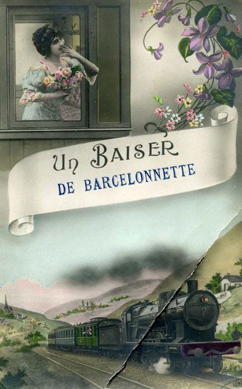
Why a Railway to Barcelonnette
It all began in 1878 with a parliamentary vote on a plan known as the Freycinet Plan, which required every prefecture and sub-prefecture to be connected by rail to the national network. Barcelonnette, the sub-prefecture of the Basses-Alpes (the former name of the Alpes-de-Haute-Provence), was necessarily required to comply with this decree, and to support the many military garrisons stationed near the Italian border in the Ubaye, such as those at the Fort de Tournoux above the village of La Condamine-Châtelard.
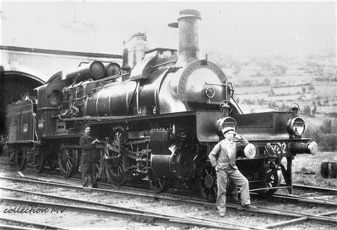
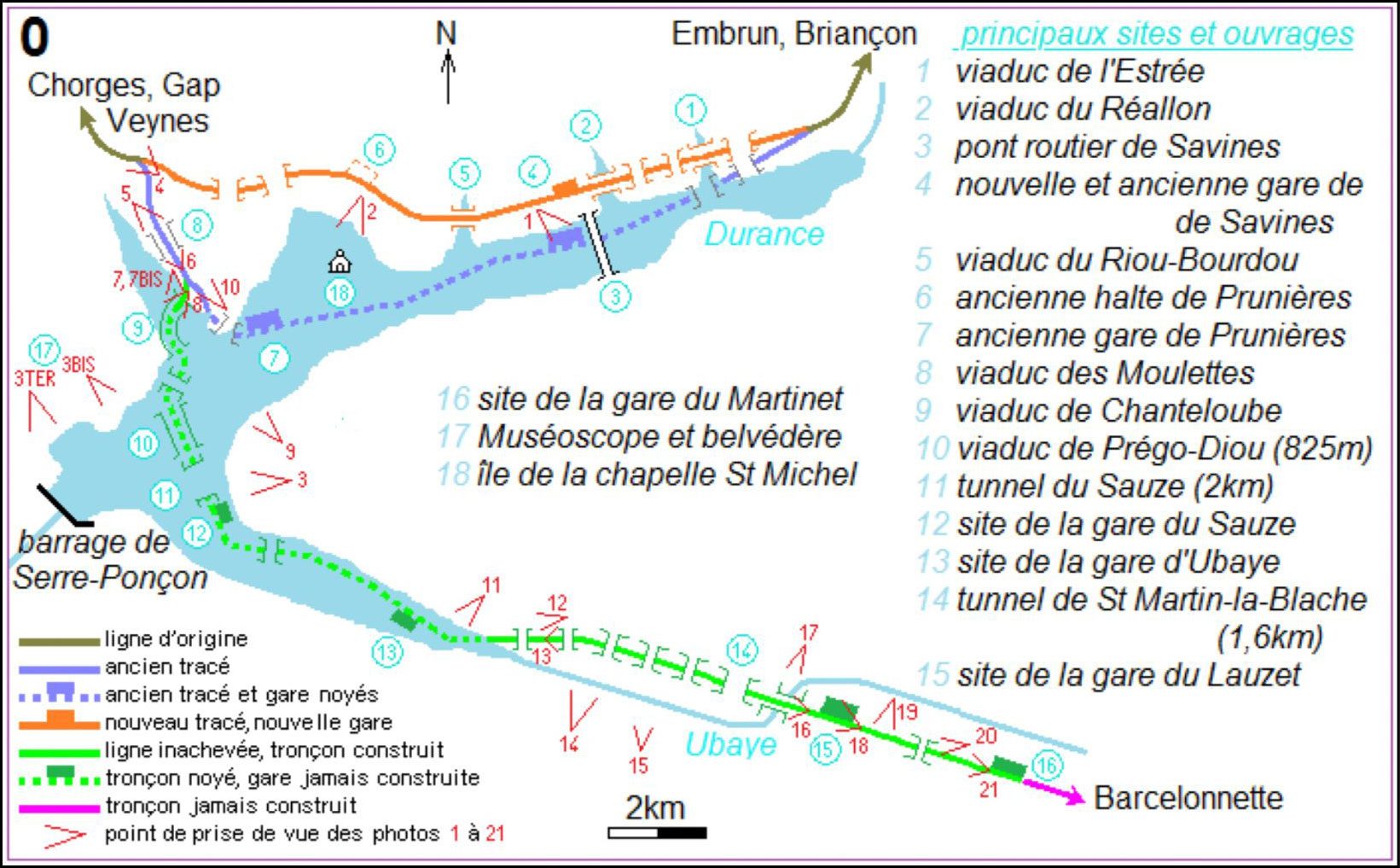
The connection to the existing national network for Barcelonnette would branch off at Chorges, on the Valence-Veynes-Briançon line, from 1909 onwards. This line from Chorges starts at an altitude of 857 metres and ends at 1,135 metres in Barcelonnette, a difference in elevation of 278 metres. The route plans for a single track over 42 km, with the construction of 27 bridges/viaducts, the boring of 11 tunnels with a combined length of 6,528 metres, and the building of 6 passing stations.
Conjointement à ce projet ferroviaire, des études s'établissent pour réaliser un barrage à Serre-Ponçon d'une surface plus réduite que celui d'aujourd'hui. Ce projet de retenue hydroélectrique sur la Durance pousse à modifier le tracé original plus en hauteur en 1911.
The Route from Chorges to Barcelonnette
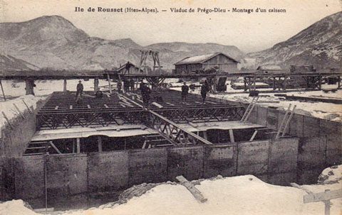
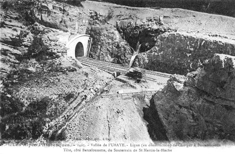
The concession was held by the Compagnie des chemins de fer de Paris à Lyon et à la Méditerranée (PLM), a private company. The second route, modified in 1911 to account for the future Serre-Ponçon lake, branches off from the Gap-Briançon line at kilometre 7703. It veers right, crossing the Moulettes torrent via the Chanteloube viaduct (built), then through the 578 m Hyvans tunnel (built), to emerge onto the Prégo-Diou viaduct spanning the Durance on five piers (partially built).
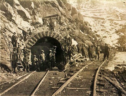
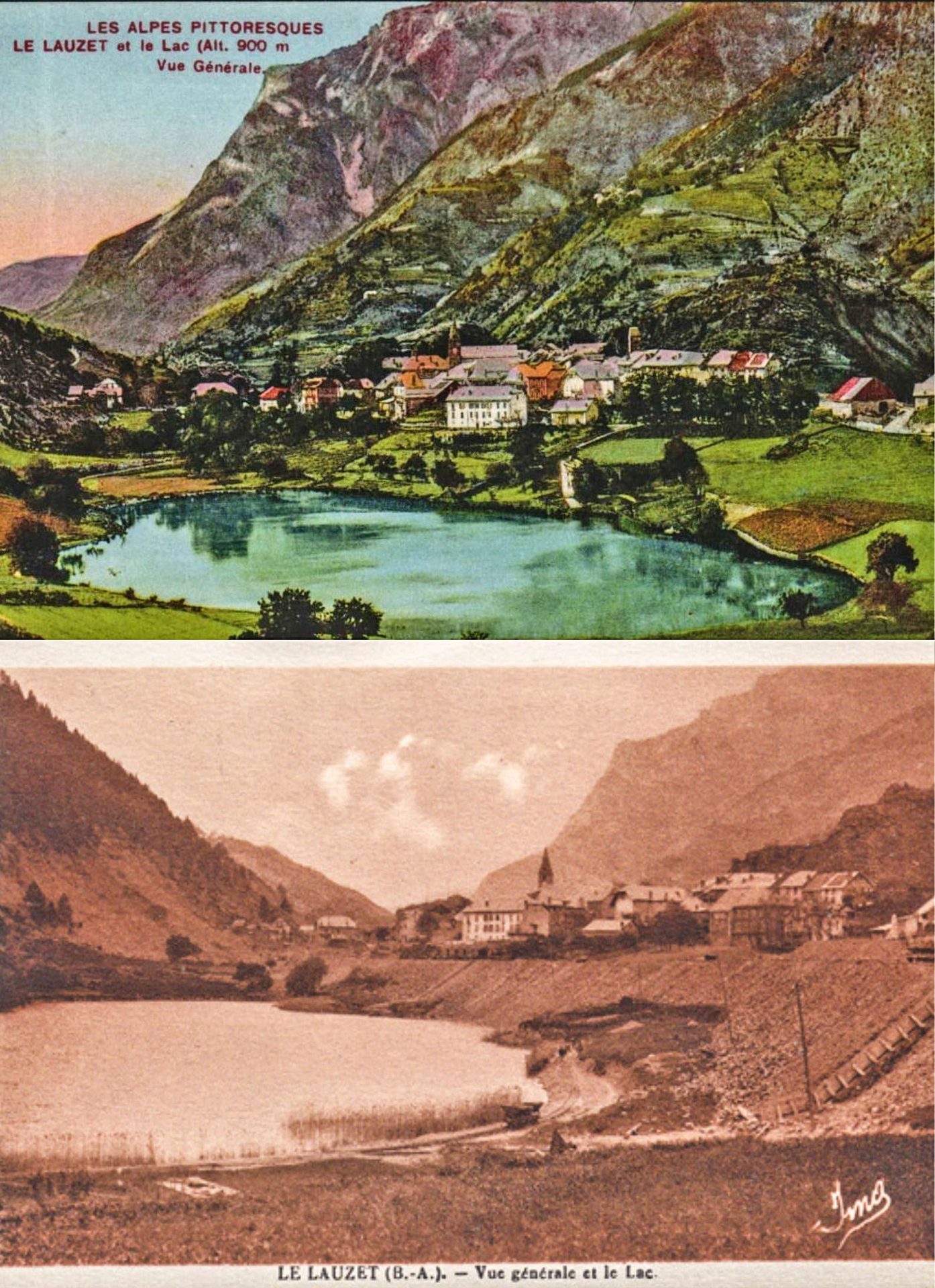
The route continues underground for 2 km through the Sauze tunnel beneath Sauze-du-Lac. It then emerges onto the Ubaye to follow its right bank through a succession of around ten small tunnels and viaducts, up to the 1.6 km Saint-Martin-la-Blâche tunnel. This last tunnel emerges near the village of Le Lauzet. Then, along Lac du Lauzet, a platform is created to launch the route which would partially narrow the lake.
Le Martinet arrêt définitif... tout le monde descend !
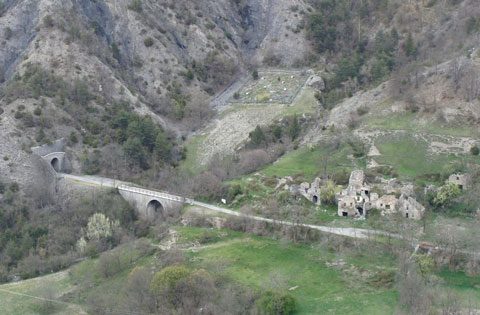
The construction of the route towards Barcelonnette continued for another 7 km to the village of Le Martinet, following a succession of retaining walls and small tunnels still visible today. The final 15 km to reach Barcelonnette, the intended destination, would never be built. In 1935, the construction site was abandoned, leaving the line unfinished.
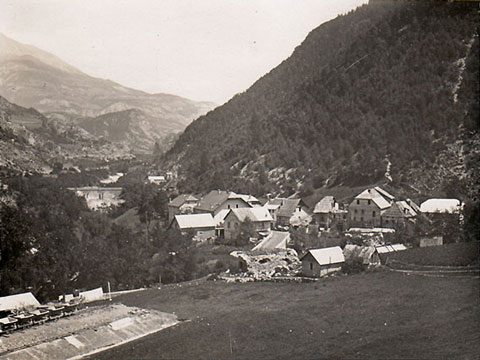
The village of Le Martinet, where the construction works on the Chorges-Barcelonnette railway came to an end. This photo, taken from a postcard written in 1933, shows the end of the line's platform with the construction wagons. Today, the Oueds & Rios base est juste derrière les wagonnets, en contrebas dans le bouquet de lilas.
Railway Hiking in the Ubaye Valley
A brief aside for those of you on holiday in the Ubaye Valley. This railway hike will take you back a century, into the incredible story of a railway line built through tunnels and aerial bridges. A unique and different way to go hiking — a wonderful physical and intellectual adventure to share as a family, before or after a great rafting trip down the Ubaye, or going hydrospeed, of course ;)
Here is the link to view the railway route and all the information you need to complete this railway hike:
Tracé de la voie
ferrée et fiche technique pour la randonnée ferroviaire
A very special mention for the two most impressive engineering works built along the Chorges-Barcelonnette line.
The Viaducts of the Ubaye
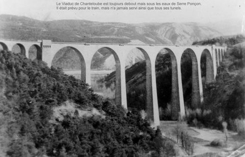
Chanteloube Viaduct
Le viaduc de Chanteloube franchissait le ravin de la Moulettes, affluent de la Durance. Il n'existait pas à l'époque un viaduc aussi élevé que lui — tout en maçonnerie, d'une hauteur de 61 mètres, avec des arches à grandes ouvertures (6 arches de 27 mètres d'ouverture) et des piles assez minces (3 m 80 d'épaisseur à la base), réduisant les dépenses et la charge sur les fondations. Tout en ayant dessus, un tablier tracé en S sur une longueur de 300 m.
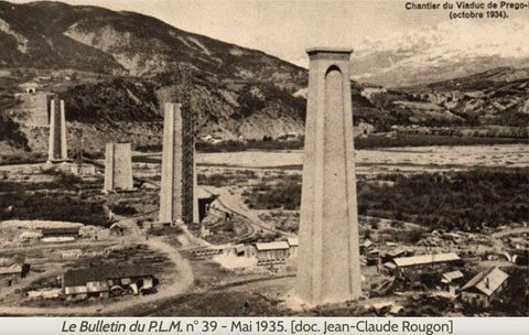
Prégo-Dieu Viaduct
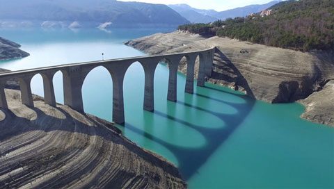
Le viaduc de Prégo-Diou (Prie-Dieu*) est un ouvrage magistral d'une longueur de 825 mètres et d'une hauteur de 72 mètres. Il enjambe la Durance en se reposant sur 5 grandes piles en maçonnerie (2 sur 5 resteront inachevées). Le tablier prévu en métal ne sera jamais posé. Construction stoppée en 1935.
The structure remained as it stood until the construction of the Serre-Ponçon dam in 1959, when it was demolished by a local company that recovered the cut stone in exchange.
(*) Paul Séjourné, l'ingénieur de l'ouvrage, craignait de possibles affaissements des piles. Il aurait déclaré : « Prions Dieu pour que ça tienne. » D'où le nom de ce viaduc en patois local : « Prego Diou ».
The Impact of a Railway Network in a Valley
A Disruption to the Local Economy
The Southern Alps rail network contributed greatly to the region's economic development. However, due to the competition from rail, travelling peddlers were pushed to seek better-paid employment. Many of them tried their luck in Mexico. As elsewhere in rural France, the agricultural economy gradually became more specialised. Crops that could be obtained elsewhere under better conditions were abandoned — gone were the flax, hemp, and high-altitude vineyards (up to 1,050 m in the Ubaye). Cereal crops gave way to livestock farming in the upper valleys.
In the Diois region, for example, traditional livestock farming gave way to the production of fattened lamb raised in stalls. In the lower valleys of the Buëch, the Durance and the Var, market garden and orchard produce benefited from easier transport and favourable rates offered by the rail network. The construction of hydroelectric dams, industrial zones (Argentière, Saint-Auban), and cement works (Paillon valley, near Nice) was made possible thanks to the presence of the railway.
The Rise of a New Economy: Tourism
Le tourisme et son développement ont été amorcés par la présence du réseau ferroviaire. Il est à la source de la réussite touristique du Briançonnais par les « express » réguliers assurés par le rail. Le Paris-Briançon est devenu une ligne quotidienne tout au long de l'année et fortement multipliée l'hiver. La preuve, à l'inverse, de l'essor tardif apporté au développement touristique de la vallée de l'Ubaye.
Progress of the Railway Construction in the Ubaye Valley
A Turbulent Progress
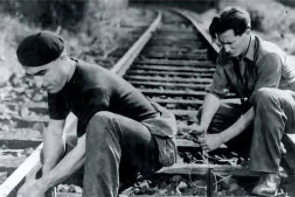
The works, interrupted by the war, resumed in 1915. In 1917, they were halted again due to a lack of labour and materials, but restarted in 1919. The workforce included Kabyle workers from Algeria — then French territory — as well as Italians, the vast majority of whom would settle in the valley. Progress in the tunnels was painfully slow... the word at the time was one of desperate sluggishness. The construction site was ultimately abandoned in 1935. It was in 1937 that the Conseil Général des Basses-Alpes officially confirmed the halt, having made headlines and caused deep disappointment among the population of the Ubaye Valley.
A Challenging Economic Climate
Slowdown and end of construction at Le Martinet in the Ubaye Valley
La Première Guerre mondiale freine la construction de cet immense projet. Les prisonniers de guerre allemands participent aux travaux durant cette période. La paix de retour, les travaux se poursuivent, la population retrouve l'espoir du train à Barcelonnette. Bien que les terrassements et la construction des ouvrages d'art aient pour la plupart bien progressé, voire été réalisés, en 1935 le sort en fut jeté.
Abandonment of the Ubaye Rail Project
The dismantling and abandonment of ongoing railway route projects in the Southern Alps.
A General Trend
Les Alpes du Sud subissent l'appartenance à un pays centralisé avec des règles uniformes, délaissant l'idée d'une politique particulière aux régions montagneuses. C'est aussi une période difficile par ses dépenses militaires. On peut imaginer dans ce contexte que localement, les intérêts privés et la pression de groupes influents orientèrent plus facilement l'abandon du projet pour un autre.
When Did This Dismantling Begin?
C'est entre 1925 et 1951, mis à part le croisement de Veynes, l'embranchement Saint-Auban–Digne-les-Bains et la ligne Nice–Digne, que tous les autres réseaux ont été abandonnés au transport des voyageurs. Abandon également d'une grande partie du trafic des marchandises (tramway Châtillon-en-Diois en 1927, tous ceux de la région de Nice, successivement fermés entre 1928 et 1932, etc.).
La guerre a eu un impact sérieux sur l'avenir du rail. Double voie entre Veynes et Argentière supprimée. Des ouvrages d'art détruits pas moins de trois fois par les différentes armées en mouvement. En 1940 : 8 tunnels et 11 viaducs ont été détruits. La ligne Nice-Meyrargues coupée en trois tronçons, circulation suspendue en 1950.
What Were the Reasons Behind This Dismantling?
Apart from the extensive war damage, the abandonment of the Southern Alps network is also explained by the same causes as in the rest of France: road competition, but with some specific details.
The lines that were closed or abandoned were not profitable given the growing depopulation of rural areas. Another reason was that road networks, with their low traffic levels, offered buses a faster and more flexible service.
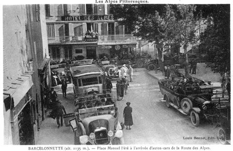
Entre les deux guerres mondiales, tout est difficile pour le rail, déjà dans une situation économique conjoncturellement désastreuse. Le chemin de fer perd des parts avec la concurrence routière et aérienne. La clientèle aisée s'oriente vers le transport individuel en acquérant son propre automobile ou en utilisant les services de plus en plus nombreux des « cars alpins » sur la route des Alpes. Cette classe de voyageurs préfère cette nouvelle façon de circuler aux wagons enfumés, aux attentes en gare et aux réactions jugées trop rigides des contrôleurs du rail.
The railways' response, through the modernisation of trams and the arrival of railcars, did demonstrate greater comfort and speed — the Nice–Digne journey was cut from 5 hours to 3 hours. But the more influential 'road lobby', backed by business-minded politicians, gradually turned the tide in favour of road transport.
Durant la création du barrage de Serre-Ponçon, il s'en est fallu de peu que le maintien des lignes au-delà de Gap soit préservé. C'est grâce à l'usine Péchiney de l'Argentière que la ligne fût conservée, et que le tourisme du Briançonnais fut sauvé de justesse.
The Reasons Behind the Abandonment of the Chorges–Barcelonnette Line
The Rise of Road Transport
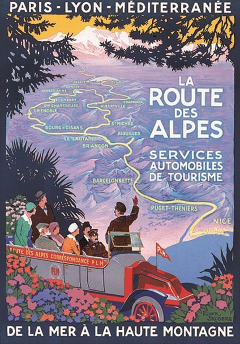
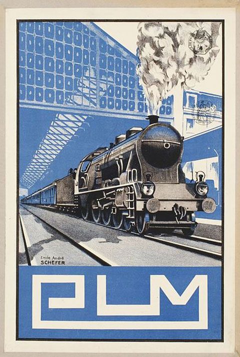
As mentioned above, one reason was the development of road transport and the pressure created by its advocates. It is worth noting that the PLM company held the concession for the Chorges-Barcelonnette railway project, but also had a foot in the road transport industry. As early as 1910, a public inquiry was conducted into the future means of transport along the road. The Paris-Lyon-Méditerranée railway company (P.L.M.) put itself forward as a candidate to develop a road transport service.
Indeed, this same company operated numerous bus routes and owned hotels linked to them. The Route des Grandes Alpes, a tourism route in successive stages, was developed jointly with the Touring-Club de France and the PLM. Not to mention the involvement of a business-minded politician with 'interests' in the road transport company — a clear conflict of interests.
Military Priorities in Decline
The military argument was also put forward as a reason for abandonment. One of the goals in building this line was to facilitate troop movements, as the Ubaye Valley remained one of the easiest crossing points through the Alps. But the priority had changed between the two World Wars. The Minister of War had made his view known as early as 1934: this route would no longer be 'of any use'.
The Barcelonnettes from Mexico
Another reason sometimes cited is the covert action of certain 'Americans' — the Barcelonnettes, émigrés du Mexique plutôt actifs à préserver leur berceau familial des dérives du progrès. Mais c'est aussi pour certains des investisseurs tout aussi actifs dans le commerce du transport routier. On déclassa la ligne le 30 novembre 1941.
Permanently Submerged by the Waters
The 1955 Serre-Ponçon dam project intended to flood the structures of the Chorges-Barcelonnette line at the confluence of the Durance and the Ubaye. While the structures and platforms of the Briançon line were relocated to a higher elevation, those of the Barcelonnette line would not be moved or replaced. The Chanteloube structure and the Hyvans tunnel were flooded. The magnificent piers of Prégo-Diou were destroyed, and the Sauze tunnel — over 2 km long, the longest in the Hautes-Alpes — disappeared beneath the waters.
Ce lien est intéressant — un inventaire des traces des ouvrages du tracé ferroviaire,
noyés par les eaux et les sédiments du lac de Serre-Ponçon :
www.tunnels-ferroviaires.org
A Breath of Hope in 1976
On espérait, après avoir vu la résurrection de deux lignes dans les Alpes-Maritimes (Cannes–Grasse et la transfrontalière Nice–Cuneo), le réveil d'un possible espoir pour l'Ubaye. Certains imaginaient possible le déblocage ferroviaire de Barcelonnette — soit par le tracé de Chorges originellement envisagé, soit par le percement d'un tunnel sous le col d'Allos pour un embranchement à Thorame de la ligne Nice–Digne. Cela ouvrirait un avenir radieux aux stations du Sauze et de Pra-Loup avec la clientèle de la Côte d'Azur.
The National Context
The Scale of Rail Dismantling at the National Level
Across France, in 1934, the creation of the 'rail-road coordination' decrees authorised the transfer to road of services previously offered by rail. This was initially a tentative start to line closures — that year, only 230 km were closed to passengers.
Mais c'est en 1938, lors de la constitution de la SNCF sous le gouvernement du Front Populaire, que le réseau ferroviaire subit une véritable razzia — plus en France qu'ailleurs en Europe. En 1938, la SNCF ferme spontanément 4 238 km de lignes aux voyageurs. En 1939, c'est 4 155 km qui disparaissent au détriment des passagers. Tout cela ouvre la place aux services des autocaristes, qui céderont progressivement la place à l'automobile individuelle après la Seconde Guerre Mondiale. Les services marchandises subissent également le même sort progressivement avant leur liquidation après-guerre. En 1940, on poursuit avec 1 403 km de ligne, puis en 1969 avec 1 721 km et en 1970 avec 1 365 km de rails.
Traces of the Railway Past, from Lac de Serre-Ponçon to the Ubaye Valley
The Current State, from Chorges to Barcelonnette
From the old embankment freed up following the rerouting of the Briançon line, one can access the site of the Chanteloube viaduct, which has become a water sports venue. The structure, submerged beneath the dam's waters, still allows the northern approach ramp to be seen. When the lake level drops, the viaduct's deck and arches emerge. It is accessible to hikers and sometimes allows a complete crossing — warning: the site is unsecured due to the absence of handrails.
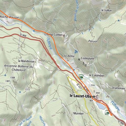
Bien après le Sauze-du-Lac, les emprises des structures ferroviaires servent à l'axe routier reliant Savines-le-Lac au village du Lauzet-sur-Ubaye. Deux premiers tunnels servent en sens unique pour chacune des directions de la route. Un autre est transformé en entrepôt.
Après l'ancien village de Roche Rousse, la ligne devient un chemin de randonnée et de VTT, avec une succession de 2 tunnels, puis la passerelle métallique de l'Enduchet (construite au début des années 2000), remplaçant le pont en maçonnerie du même nom, dynamité par des Allemands en fuite vers l'Italie lors de la Seconde Guerre Mondiale.
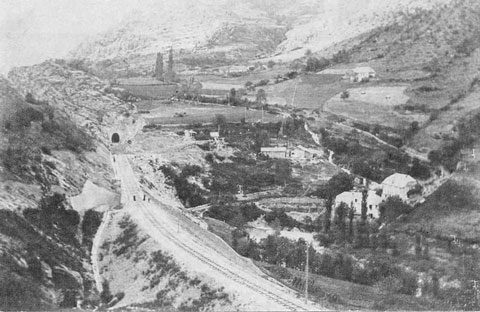
You then reach the entrance to the Saint-Martin-la-Blâche tunnel, 1.614 km long, which at its far end spans the Ubaye via a viaduct to emerge at Le Lauzet. The tunnel is not lit and requires a head torch to traverse. It was used as a mushroom farm in the late 1980s.
À partir du Lauzet jusqu'au Martinet, les plateformes et soubassements de l'ancienne ligne ont été aménagés comme dédoublement de l'axe routier menant à Barcelonnette. On aperçoit sur la route d'admirables édifications de murs de soutènement en pierres de taille.
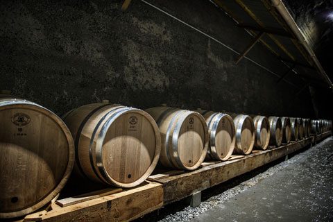
Just before the village of Le Martinet, the Bouille tunnel (644 m) is divided in two: one half is used to age the tomme cheeses of the Barcelonnette fromagerie, the other houses the whisky 'Le Laverq' from the artisan distillery of Lachanenche-de-la-Fresquière, in the commune of Méolans-Revel.
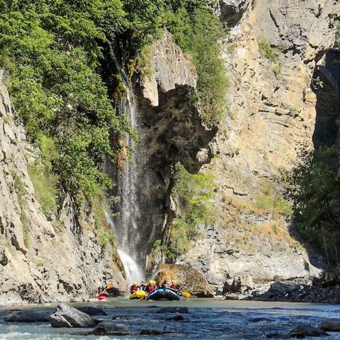
Visible at the entrance to the village of Le Martinet is the last structure of this pharaonic construction site: two retaining walls supporting the access ramp to the road leading to the magnificent Laverq valley. The Oueds & Rios rafting base on the Ubaye Oueds & Rios est située à 20 mètres en contrebas de l'endroit où le dernier coup de pioche s'est réalisé lors de cette folle épopée du rail ubayenne.
Tunnels Auctioned Off in 1986
Acquisition des tunnels de l'Ubaye mise aux enchères à Digne dans les Alpes-de-Haute-Provence. Mise de départ pour chacun de ces ouvrages : 200 francs pièce.
- Tunnel de Combas (198 m) ; tunnel de Roche Rousse (236 m) ; tunnel de Derbezi (442 m) — acquis par la commune du Lauzet à 50 800 francs / 7 744 €.
- Saint-Martin-de-la-Blâche tunnel (1,614 m) — purchased by the commune of Le Lauzet for 56,500 francs / €8,613.
- Tunnel de Bouille (614 m), où fromagerie et whisky s'affinent de nos jours — acquis par la commune de Méolans-Revel à 48 000 francs / 7 317 €.
A Lost Battle... or the Uniqueness of a Preserved Valley
Let us imagine what our beloved Barcelonnette Valley might have been like with a railway line. The presence of such an installation at the bottom of the valley would inevitably have created a very different atmosphere.
In other Alpine valleys where the train exists, its impact is plain to see. It transforms natural landscapes and disrupts sites. The network separates communities and passages, although structures like tunnels help it blend in better. The economic development that the railway would have generated would have had a significant local impact — activities would have developed or been sustained.
(photo Camille OLIVE / Oueds & Rios)
À contrario, on peut penser que d'autres secteurs auraient succombé par le transport sur rail, plus aisé, de certains produits manufacturés plus compétitifs que l'artisanat ou la culture locale. Le chemin de fer aurait peut-être apporté son cortège de nuisances : entreprises polluantes ou prélevant plus massivement les ressources naturelles (bois, carrière, élevage intensif...). Une population plus nombreuse, des zones d'habitation plus vastes et plus denses. Des structures touristiques plus développées empiétant sur les zones naturelles. Le réseau routier se serait développé tout autant pour répondre à certaines attentes, engendrant un impact désastreux en fond de vallée. Et certainement une vision toute différente aux abords de notre belle rivière Ubaye.
Mais n'oublions pas ce que le train aurait pu apporter à la vie de la population de la vallée de l'Ubaye. Le rail aurait symbolisé une certaine ouverture et un accès plus aisé vers l'extérieur pour les Ubayens sortant de deux guerres mondiales. On pourrait y voir l'accélération d'un désenclavement social et culturel, et pour beaucoup une qualité de vie plus confortable.
Une bataille perdue pour de nombreux Ubayens, et une vallée préservée pour ceux qui apprécient aujourd'hui la singularité de cette si belle vallée de l'Ubaye.
« Quand l'homme n'aura plus de place pour la nature, peut-être la nature n'aura-t-elle plus de place pour l'homme. »
— Stefan Edberg
Illustrations — Sources
- Jean-François André DÉLÉNAT : ubaye-en-cartes.e-monsite.com
- Maps and photos taken in 1920 by Casimir Riollan, electrician in Le Lauzet (coll. Laurent Delimard)
- Les Chemins de fer dans les Alpes du Sud : passé, présent, avenir — Jean Guiter, Revue de Géographie Alpine, 1976, Imprimerie Allier, Grenoble.
- Florent COSTE, Wikipedia contributor.
À lire aussi : Qui sont ces radeliers et mariniers ?
